


Subproject G6: Plateau formation recorded by tectonic and climatic signals in intramontane basins in NW Argentina
Research Field: Structural Geology, sedimentology, geochronology, isotope geochemistry
-
Research staff
-
Working area
-
Abstract
-
Objectives, methods, work plan, and schedule
-
Collaboration with external research groups
-
Publications
Staff
Project-Leader(s)
Co-Leader(s)
Members
Working area of the subproject G6
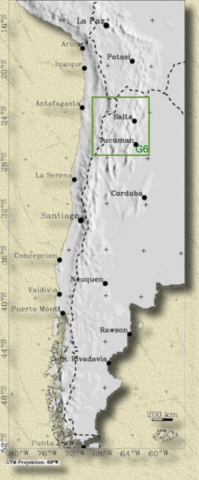
Fig. 1: Working area of project G6
Abstract
Continental plateaus constitute important topographic manifestations of geodynamic processes but factors controlling the formation of such high-altitude regions typically associated with small differences in relief are still not well understood. Next to Tibet, the Andean Altiplano/Puna Plateau is the second largest plateau province on Earth and has had a sustained influence not only on the endogenic evolution of the Andes and adjacent regions but most likely also on the atmospheric circulation of the southern hemisphere. Several mechanisms accounting for the Altiplano/Puna Plateau have been proposed, but the onset of plateau formation and whether it occurred in increments that may well have differed spatially are still uncertain. More importantly however, the effects of the climate on the formation and transient conservation of the plateau surface have not been addressed in previous studies. Our proposal is designed to provide answers with respect to both, endogenic forces and the role of climatic changes on plateau formation in the southern central Andes. Changes in topography and climate along the meridionally trending Andes are expected to be recorded in the sedimentary rocks of Neogene intramontane basins. Thus, we propose to decipher mechanisms of plateau formation including (1) lithospheric delamination, (2) various modes of crustal shortening and (3) effects of aridification by identifying vestiges of the respective sedimentological and structural processes responsible for vertical and lateral plateau growth during late Cenozoic time. In addition, the effects of plateau formation with respect to the evolution of climate, the asymmetric spatial distribution of surface processes and consequent differences in mass-flux will be studied using proxy-indicators in intramontane basins. This will be carried out by studying the sedimentary history of selected basins, provenance and paleosols of their sedimentary infill as well as by quantifying ages and rates of differential uplift/denudation of the basin margins using the apatite fission-track method. The complementary analysis of stable isotopes of carbon and oxygen will unravel progressively changing paleo-ecologic conditions during basin formation. With these new data sets we hope to differentiate between competing processes of plateau formation and understand spatial and temporal plateau formation in a non-collisional mountain belt.
Objectives, methods, work plan, and schedule
Objectives:
Lithospheric delamination, horizontal contraction, and climatically controlled erosion processes operate on distinct temporal and spatial scales and would, therefore, be expected to produce characteristic geologic signals reflected in the Neogene record of the central Andes. Horizontal crustal shortening resulting in vertical thickening in the central Andes may have been accomplished either by distributed or localized deformation, i.e. "pure shear" and "simple shear" modes of deformation, respectively (Allmendinger and Gubbels, 1996; Allmendinger et al., 1997). Distributed deformation apparently was dominant in the Puna and occurred over the entire crustal (lithospheric) column and a finite initial width of tectonized area. By contrast, localized deformation prevailed in the Altiplano and was accomplished by westward underthrusting of crust at the eastern edge of the plateau along a mid-crustal detachment surface above which horizontal shortening was accommodated chiefly by east-verging fold-thrust imbrication of upper crustal units. Thus, crustal thickening in the Altiplano was achieved by eastward propagating deformation fronts on the plateau and in its eastern foreland. Both modes of deformation should be coeval with rock exhumation and most likely also surface uplift since the beginning of the Neogene. Delamination of lithospheric mantle, however, operates on much shorter time scales than the above deformation modes (e.g., Kay et al., 1994) and is generally accompanied by horizontal tension (England, 1993). In light of the Oligocene deformation history in the Puna (e.g., Kraemer et al., 1999; Coutand et al., 2001) delamination and resulting surface uplift in the present plateau area postdate horizontal contraction and thus should be recorded in the exhumation history of the plateau-bounding mountain ranges and within the sedimentary sequences within and outside the plateau.
Based on geophysical, geological and climatic differences between the Puna and the Altiplano, we devised a working hypothesis that includes a chain of related geodynamic processes. These can be tested by several independent data sets already available and supplemented by data from the Tertiary basins and their flanks. Several lines of evidence suggest that Andean deformation started in thermally and structurally weakend crust of the Cretaceous-Paleogene Salta Rift and lead to vertical thickening and consequent surface uplift of the Proto-Eastern Cordillera (e.g., Vandervoort et al., 1995; Coutand et al., 2001). This proto-range may have exerted a profound climatic influence as an orographic barrier, resulting in accumulation of sediments with different sedimentologic, paleo-ecologic and paleo-climatic characteristics in the prospective plateau to the west, and the adjacent foreland basin in the east. Upon reaching a critical crustal thickness and surface elevation in the proto-Eastern Cordillera, horizontal shortening was preferentially concentrated in prestrained Paleozoic meta-igneous and -sedimentary belts in the evolving plateau. Following attainment of critical crustal thickness and surface elevation in this area, deformation shifted to the current deformation front along the foothills of the Eastern Cordillera.
Limited available data from the eastern margin of the Puna between 24?S and 27?S document that intramontane basins on the Puna margin can be built within a few million years by eastward-migrating deformation and uplift. At the same time, a significant precipitation gradient which increasingly aridified the Puna and bordering regions migrated eastward. From these starting conditions, the basins along the Puna margin can become indistinguishable from the plateau itself. After becoming internally-drained, the sedimentary basins received an enormous quantity of detritus in their early stages of development, so that they could be filled up to their watershed divides (Sobel et al., 2000; Strecker et al., 2000), apparently allowing the Puna plateau to expand laterally in a manner similar to the lateral plateau growth and basin development described from the northeastern margin of the Tibetan plateau (Meyer et al., 1998; Sobel et al., submitted). However, in contrast to the drier northern Tibetan regime, the Puna margin basins appear to be more short-lived, because the regional rainshadow lies immediately adjacent to the basin margin. Higher precipitation can cause headward erosion as well as landsliding, thereby breaching the previously internally-drained basins. Subsequently, sediment stored in these basins will be evacuated and transported into the foreland region (Strecker et al., 2000).
The Quaternary phase of downcutting and basin exhumation in these intramontane basins permits a three-dimensional study of basin evolution, which until recently characterized lateral plateau growth. These areas are thus well suited for this study because they bear important clues for understanding the formation of the central Andean plateau. Therefore, we aim to study the Neogene Angastaco, El Cajon and Bolson basins along with their margins located at the eastern rim of the southern Puna, as well as the Antofalla basin within the Puna (Figure 1). These basins are already well known to the authors from previous studies and published information on ages of sedimentary sequences (Strecker et al., 1989; Grier, 1990; Bossi et al., 1999; Kleinert & Strecker, in press). The basins are located on a transect between areas in which ages of deformation and rock exhumation are known (Andriessen and Reutter, 1994; Coughlin et al., 1998; Sobel et al., 1999; Sobel & Strecker, in prep.). Thus, their strategic position is also expected to provide information as to spatially migrating deformation and consequent plateau formation. By studying the interaction between the evolution of these basins along with deformation, exhumation and erosion of structural highs, we hope to furnish important constraints with regard to the competing climatic and tectonic forces during the evolution of the Puna and continental plateaus in general. Our study will include analyses of (1) sedimentary provenance, (2) morphology and stable isotope signatures of paleosols as well as (3) apatite fission-track thermochronology on the basin infill and igneous rocks of the respective basin margins that will be complemented by (4) structural analysis of pre-Andean discontinuities.
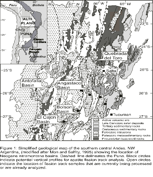
Fig. 2: Text aus Graphik ergänzen
Methods
Fission track analysis and structural interpretations: Fission track (FT) thermochronology is a powerful tool used to unravel the low-temperature thermal histories of orogenic belts (e.g., Wagner and Van den haute, 1992). For relatively low temperature histories (about 125-60?C and 300-250?C), applicable when the rocks were approaching the earth's surface, the principle method for obtaining this time-temperature information is apatite and zircon fission track thermochronology (e.g. Green et al., 1989a, 1989b; Tagami et al., 1996). Use of fission-track methods for reconstructing cooling histories relies on the facts that (1) tracks accumulate at a well-defined rate from the fission decay of trace 238U, allowing calculation of fission track ages, while, at the same time, (2) tracks are erased by thermal annealing at elevated subsurface temperatures. Annealing may be partial, reducing the apparent fission-track age and shortening the lengths of individual tracks, or total, resetting the fission-track age to zero (e.g., Wagner and Van den haute, 1992).
Interpretation of fission track data involves the analysis of several fission track parameters in addition to the sample fission track age. Because each track forms at a different time from fission of a single 238U atom, the track length distribution records details of the t-T path which may be recovered by modeling to determine the spectrum of t-T paths consistent with the observed data (e.g., Wagner and Van den haute, 1992; Gallagher, 1995). Apatite single-grain age data are useful because different apatite grains in a sample may anneal at somewhat different temperatures, a kinetic effect related to the differing chemical composition of the grains (Carlson et al., 1999). Thus, exposure to certain temperatures may totally anneal some grains and reset their ages to zero, while other grains are only partially annealed. In this case, ages of the youngest, totally reset grains may date exhumation and cooling (e.g., Sobel and Dumitru, 1997).
Under favorable circumstances, FT ages can be used to quantify vertical motion of rocks with respect to the present surface (rock exhumation). An exhumed partial annealing zone (PAZ) can often be detected by sampling thick, coherent, preferably vertical, rock sections. The slope of the FT age vs. elevation curve in non-tilted sections indicates the rate of exhumation (denudation). A sharp kink in this curve often denotes the base of a fossil PAZ and its FT age the onset of the exhumation process (e.g., Brown, 1991). If the paleo-mean surface temperature, the paleogeothermal gradient and the elevation difference between the base of the fossil PAZ and the present mean surface for a particular area are known, it is also possible to estimate the thickness of material removed by erosion or tectonic denudation. Such calculations are based on the assumptions that cooling of rock is entirely due to exhumation and that the paleogeothermal gradient is constant. Apatite FT thermochronology from rocks located on either side of major reverse faults with known dip may be able to provide quantitative estimates for the age and onset of fault activity, magnitudes and rates of both horizontal contraction and displacement on the fault (Wagner and Van den haute, 1992).
Of particular importance for assessing the interaction between erosion, tectonism and plateau formation in the central Andes is the knowledge of erosion patterns and their evolution with time (e.g., Sanders et al., 1999) across the eastern Puna and adjacent Cordillera. The high ranges of this region are ideal targets for such analysis. In order to link FT thermochronology of the ranges with the evolution of late Cenozoic basins (see below), ranges bordering these basins and thrust over the respective sedimentary infill were selected for FT analysis. In combination with previously sampled vertical sections in the eastern Puna and Eastern Cordillera, these terrains delineate two transects. One crosses the southern Puna and Eastern Cordillera from west of the Salar de Arizaro to the Sierra de Metan and consists of at least 10 vertical sections. The other is a longitudinal transect along the eastern margin of southern Puna from the Humahuaca Valley to the Pampean Ranges and will consist of more than 12 vertical sections. The spatial and temporal variation of deformation inferred from rock exhumation on the transverse transects will decide on the relative importance between distributed and localized, i.e. propagating deformation and the time frame in which deformation occurred in the Puna. Similarly, unraveling these quantities on the orogen-parallel transect will bear on the rate of lateral growth of the plateau by crustal shortening. The comparison of these results with equivalent information from the Altiplano generated by project G7 will show wether the Altiplano and the Puna differ fundamentally in their tectonic evolution or rather indicate different stages of the same process of plateau formation.
Depending on the chronologic and spatial distribution of exhumation, we hope to distinguish between the effects of (1) lithospheric delamination that should result in a relatively short but recent (i.e. post 4 Ma) increase in erosion, (2) crustal shortening, expected to be apparent by constant erosion lasting for most of the Neogene and (3) development of an orographic barrier evident by enhanced pre-Neogene exhumation in the Eastern Cordillera. Moreover, the erosion pattern across the eastern margin of the southern Puna may show whether the Eastern Cordillera constitutes the geometry of a deforming wedge and thus, a basal detachment surface, a possibility that has not yet been explored by means of geophysical imaging. The erosion pattern may also indicate the climatic influence on tectonism, in particular vertical mass transfer, by e.g. tracing migrating belts of increased exhumation that may correspond to zones of maximum precipitation (e.g., St?we and Hinterm?ller, 2000). This will provide natural input parameters recording crustal deformation, associated plateau evolution, and erosion for distinct and finite element modeling planned in project G2.
Detrital apatite and zircon grains deposited within a sedimentary basin can provide information on the exhumation history of the sediment source area, assuming that there is sufficient exhumation for reset grains to reach the surface (e.g.. Garver et al., 1999; Steinmann et al., 1999). Preliminary results from the Aconquija and Cumbres Calchaquies ranges suggest that apatite grains within the Puna margin may record Cenozoic exhumation while zircons will likely record provenance information (Sobel et al., 1999; Sobel, unpublished). The difference between the age of reset detrital apatite grains deposited within a basin and the depositional age of the strata which hosts the detritus will record the interval between cooling (exhumation) through 90-60?C to the surface, and transport to the depositional area (e.g., Cervany et al., 1988; Garver et al., 1999). As transport is typically quite rapid, the lag time principally reflects low-temperature exhumation. Different apatite and particularly zircon age groups can often be linked to discreet source areas, providing information on provenance (e.g. Garver et al., 1999). Combining fission-track data from detrital strata within the basin and from vertical transects through the surrounding ranges will lead to a better evaluation of the mass of material eroded from the hinterland and subsequently deposited in the basin. Detrital zircons from reworked volcanic ashes can also constrain the depositional age of the strata (e.g. Steinmann et al., 1999). The temporal change of sediment volume in the Subandean foreland basin generated by project G8 will be compared to the corresponding change in denudation of the ranges within the Eastern Cordillera. The volumetric difference between the two furnishes a quantitative estimate on sediment flux through transient intramontane basins. Moreover, the change in wavelength of intramontane basins over time provides quantitative information necessary for calculating flexural rigidity of crust at critical stages of plateau evolution that will be performed in project F4.
Provenance analysis: Provenance analysis can assist in determining the contribution of different hinterland source rocks to deposition in sedimentary basins and understanding the exhumation of tectonically active areas of the Puna plateau. The presence of specific detrital components and their variation in a stratigraphic sequence can be explained by a complex interaction between tectonic activity, long-term climate fluctuations and changes in the depositional environment (Blatt et al., 1980; Valloni and Maynard, 1981; Dickinson, 1985; Valloni 1985; Zuffa, 1985; Ibbeken and Schleyer, 1991). Separating the influence of these factors requires an investigation of a large set of samples as well as a number of variables such as grain-size distributions, clast petrography, mineral assemblages, fossil content and geochemistry. In the proposed project, the provenance of the Tertiary sediments will be determined by (a) clast counts in the field and thin-section point counting (Chayes, 1956; Galehouse, 1971), as well as (b) chemical analysis of the sand fraction (Hickman and Wright, 1983). These techniques were successfully used in provenance studies in other regions of the Andean foreland (e.g., Reynolds et al., 2000). Furthermore, heavy mineral assemblages, isolated as a byproduct of fission-track sample preparation, will be studied to better define provenance (Morton, 1985). The resultant multi-dimensional data sets will be analyzed using multivariate statistical procedures, especially principal component and cluster analyses, in order to determine temporally varying contributions of certain lithologic units and their significance with respect to the migration of tectonic activity (e.g., Davis, 1986; Ibbeken & Schleyer, 1991). This provenance information will be further compared with spatial shifts of sediment paleocurrent data. High-resolution age control is possible using published stratigraphic sections constrained by magnetostratigraphy supplemented by Ar/Ar dating and tephrochronology (Strecker et al., 1989; Reynolds et al., 2000; Marrett and Strecker, 2000). Utilizing this database, the contributions of the different sediment sources over time can be used to determine one-dimensional flux rates; in combination with balanced profiles and subsidence data this leads to the determination of three-dimensional sediment flux rates in time and space. Finally, these mass balances can be assessed in light of exhumation rates derived from the fission-track study.
Morphology of paleosols: Our previous studies of NW Argentine sedimentary basins have shown that paleosols are useful indicators of paleoecologic conditions during the time of soil formation during or following sedimentation (Strecker et al., 1989; Kleinert & Strecker, in press). Important parameters for soil formation are the availability of water and the resulting vegetation cover. These are factors that are intimately related to the prevailing climatic conditions, which are strongly influenced by the meridionally trending orographic rainshadow imposed by the Andes, which blocks moisture laden eastern winds. A study of characteristic paleosol horizons is thus a perfect tool to assess spatial and temporal changes in climate and vegetation. Characteristic horizons, soil structures, authigenic minerals, degree of preservation and developmental stage of paleosols are furthermore useful to evaluate sedimentation rates and drainage conditions (Retallack, 1985; 1988; 1990; Zaleha, 1997). On a first order basis, this method allows one to detect the onset of uplift of important orographic barriers and resultant aridification in the Puna itself and the adjacent intramontane basins.
Stable isotopes in paleosols: The carbon and oxygen isotope ratios of authigenic minerals in paleosols record important information on elevation, climate and vegetation cover during soil formation. The d13C values of pedogenic carbonate are, through plant-respired CO2 in the soil, controlled by the predominant vegetation type. In sediments post-dating the upper Miocene global expansion of grasslands they can be used to distinguish between 3 broad types of plant ecosystems: 1) ecosystems dominated by C3 plants (scrubs, trees) which are characteristic of relatively humid climates, 2) ecosystems dominated by C4 plants (grasses) which are characteristic of relatively arid climates, and 3) mixed C3/C4 ecosystems (Cerling et al., 1989; Quade et al., 1995). Correspondingly, d13C values of pedogenic carbonate can provide important information on paleo-climate and, in combination with d18O values, also on paleo-topography. Specifically, increased aridity due to the formation of a rainshadow behind a rising orographic barrier may be indicated by a transition from a C3-dominated plant ecosystem to one dominated by C4 plants. The d18O values of pedogenic minerals (e.g., calcite, kaolinite, smectite) are, through the soil water, controlled by the oxygen isotope composition of surface waters, and record important information on paleo-relief and -elevation. During the formation of an orographic barrier, the increase of precipitation on the windward side of mountain belts causes a pronounced increase of the d18O values of the remaining atmospheric moisture, and results in a corresponding decrease of the d18O values of precipitation on the leeward side. As a consequence, d18O values of pedogenic minerals can be used to reconstruct the formation of orographic rainshadows from deposits on the leeward side of uplifting orographic barriers, and, depending on the decrease in d18O values, may well provide quantitative constraints on the magnitude of the surface uplift (Chamberlain et al., 1999; Blisniuk et al., 1999, in prep.). The significance of paleo-elevation changes at the studied sites, which also control the d18O values, can be estimated from the integration of the oxygen isotope data with independent climate information from carbon isotope analysis, soil morphology and fossil plant assembleges. The stable isotope work proposed here will be carried out by Peter Blisniuk in collaboration with Prof. Page Chamberlain, Dartmouth College (Hanover, NH, USA), and Prof. Libby Stern, University of Texas (Austin, TX, USA). Both collaborators have extensive experience with similar work from own previous studies in the NW-Himalayan foreland (Stern et al., 1997), the Southern Alps of New Zealand (Chamberlain et al., 1999), and from the ongoing collaboration with Blisniuk in the Patagonian Andes (Blisniuk et al., 1999, in prep.). For the isotope analyses, well-equipped laboratories are available at both collaborating institutions and can be used on a self-cost basis.
Work plan and schedule
2002
Argentina. First sample collection from the Angastaco, El Caj?n and El Bols?n / Coral Quemado sedimentary sections (25? to 30?S) for detrital-fission track analysis, provenance and isotopic studies. This will be accompanied by sampling vertical rock sections for fission track analysis from ranges bordering on the respective basins (Fig. 1). Furthermore, a field-based structural analysis of the fault-bounded flanks of the Luracatao and Calchaqui - Santa Maria Valleys (between 25?45' and 26?15') in collaboration with Dr. Fernando Hongn (UNSa) pertains to understanding the significance of reactivated pre-Neogene (rift-related) structures on rock exhumation. Conglomerate clast counting for provenance analysis. Identification, systematic description and classification of paleosols, collection of fossil leaf assemblages for physiognomic and environmental studies (Argentinean partner Dr. R. Alonso). Structural characterization of sedimentary sections.
Potsdam. Sample preparation: mineral separation for fission-track samples, tephrochronology, Ar/Ar dating and provenance analysis; thin section preparation, irradiation and analysis of fission-track samples. Microstructural description of pedogenic carbonate samples, sample preparation and isotopic measurements (P. Blisniuk and C.P. Chamberlain, collaborative work at Dartmouth College, USA). Processing of structural information gained from pre-Neogene structures reused during Andean tectonism including the generation of structural and geological maps and construction of the respective profiles as well as an orientation analysis of discontinuities. This will be complemented by preparation of structural samples for thin section analysis.
2003
Argentina. Collection of supplementary samples from the three sedimentary profiles based on preliminary results from 2002. Conglomerate clast counting for provenance analysis. Additional sampling, systematic description and classification of paleosols. Facies descriptions for the profiles in collaboration with Argentinean colleagues. Field-based structural analysis of pre-Neogene structures of the flanks of the Luracatao and Santa Maria Valleys (this will be carried out only by Dr. Fernando Hongn).
Potsdam. Sample preparation: mineral separation for fission-track samples, tephrochronology, Ar/Ar dating and provenance analysis; thin section preparation, irradiation and analysis of fission-track samples. Sample preparation and isotopic measurement of new pedogenic carbonate samples. Ar/Ar dating of volcanic ashes; microprobe analysis to correlate these ashes with previously dated and geochemically characterized ashes from adjacent basins. Quantitative provenance analysis including petrographic point counting from stained thin sections and geochemical fingerprinting assisted by statistical analysis such as PCA and cluster analysis utilizing Matlab?. Subsidence analysis and mass flux modeling. Processing further structural information (structural maps, profiles and diagrams). Inspection of thin sections from tectonites. Analysis of fission track samples including counting, track length measurement and modeling. Preparation of a manuscript on reactivated rift structures in the Eastern Cordillera and first results of a fission track analysis.
2004
Potsdam. Continuation of basin analysis and geochronologic studies. Assessment of results in a regional context; comparison of plateau development scenarios with the Tibetan plateau, where the workers also have experience. Paleo-environmental characterization of the depositional environment utilizing the results from paleosol and plant assemblage characterizations (joint study with Argentine colleagues), as well as paleoclimate reconstructions utilizing isotopic data from pedogenic carbonates. Further analysis of fission track samples including counting, track length measurement and modeling. Derivation of a model of plateau- and foreland basin development; presentation of results at international congresses and publication of results in international journals.
Collaboration with external research groups
Names of important partners in the host countries
Argentina:
-
Dr. Ricardo Alonso, UNSA, Salta. Collection of fossil plant materials in several Tertiary formations within the Puna and intramontane basins in order to perform paleo-altimetry and paleo-ecological assessments.
-
Dr. Fernando Hongn, UNSA, Salta. Structural analysis of pre-Neogene structures.
-
Prof. Jos? Viramonte, UNSA, Salta. Collection and geochemical identification of volcanic ashes in Tertiary basin sediments.
-
Prof. Ricardo Mon, UNT, Tucumán. Collaboration on questions pertaining to the structural evolution of the northern Sierras Pampeanas.
-
Dr. Arturo Villanueva, UNT, Tucumán. Definition of sedimentary environments for Tertiary units in the Bolson basin.
Publications
Literature
Reviewed publications
Bookhagen, B., Haselton, K.R. and Trauth, M.H. (2001): Hydrological modelling of a Pleistocene landslide-dammed lake in the Santa Maria Basin, NW Argentina. - Palaeogeography Palaeoclimatology Palaeoecology, Vol. 169: 113-127.
Haselton, K., Hilley, G., Strecker, M.R. (2002): Controls on mountain glaciation and paleoclimate implication: evidence for stable climatic patterns in the southern Central Andes. - Journal of Geology, v.110: 211-226.
Hermanns, R, Trauth, M.H., Michael McWilliams, Strecker, M.R. (2000): Tephrochronologic Constraints on temporal Distribution of large Landslides in NW-Argentina.. - Journal of Geology, 108: 35- 52; . - []
Hermanns, R. L. and Strecker, M. R. (1999): Structural and lithological controls on large Quaternary rock avalanches (sturzstroms) in arid northwestern Argentina lithological controls on large Quaternary rock avalanches (sturzstroms) in arid northwestern Argentina. - GSA Bulletin America Bulletin America Bulletin, 111(6): 934-948.
Hermanns, R.L., Niedermann, S., Strecker, M.R. (2001): Neotectonics and catastrophic failure of mountain fronts in the southern intra-andean Puna plateau-. - Geology, 29: 619-623; . - []
Hermanns, R.L., Strecker, M.R. (1999): Structural and lithological controls on large Quaternary rock avalanches sturzstroms) in and northwestern Argentina.-. - GSA Bulletin, 111(6): 934- 948; . - []
Hindle D. (2003): Finite strain variation along strike in mountain belts. In 'New Insights into Structural Interpretation and Modeling' ed. D.Nieuwland. - Special Publications of the Geological Society of London, : ; . - []
Hindle, D., Kley, J., Klosko, E., Stein, S., Dixon, T., Norabuena, E. (2002): Consistency of geologic and geodetic displacements in Andean orogenesis. - Geophysical Research Letters, : ; . - []
Kleinert, K., Strecker, M.R. Climate change in response to orographic barrier uplift: paleosol and stable isotope evidence from the late Neogene Santa Maria basin, northwestern Argentina.. - GSA Bulletin, : ; . - []
Marrett, R., Strecker, M.R. (2000): Response of intracontinental deformation in the Central Andes to Late Cenozoic Reorganisation of South American Plate Motion.-. - Tectonics,, 19: 452- 467; . - []
Marwan, N., Trauth, M.H., Kurths, J. ENSO and mass movements in the NW Argentine Andes. - Climate Dynamics, submitted manuscript.
Niedermann, S., Hermanns, R.L., Strecker, M.R. The chronology of giant landslides at the Sierra Laguna Blanca, Argentina, as deduced from cosmogenic 21 Ne.. - Earth and Planetary Science Letters, submitted manuscript.
Riller, U., & Oncken, O. (2002): Growth of the central Andean Plateau by tectonic segmentation is controlled by the gradient in crustal shortening.. - Journ. of Geology, Vol. 111: 367-384.
Riller, U., Greskowiak, L, Ramelow, J. and Strecker, M. (1999): Dominant modes of Andean deformation in the Calchaqui River Valley, NW-Argentina. - XIV Argentine Geological Congress, Actas 1: p. 201-204.; Salta. - []
Riller, U., Petrinovic, L, Ramelow, 1, Greskowiak, L, Strecker, M., and Oncken, 0. (2001): Late Cenozoic tectonism, caldera and plateau formation in the central Andes.. - Earth and Planetary Science Letters, 188: 299-311; . - []
Strecker, M.R. and Marrett, R. (1999): Kinematic evolution of fault ramps and role in development of landslides and lakes in northwestern Argentine Andes. - Geology, 27(4): 307-310.
Trauth, M.H. and Strecker, M.R. (1999): Formation of landslide-dammed lakes during a wet period between 40,000 - 25,000 yr B.P. in northwestern Argentina. - Palaeogeography, Palaeoclimatology, Palaeoecology, 153/1-4: 277-287.
Trauth, M.H., Alonso, R.A., Haselton, K.R., Hermanns, R.L., Strecker, M.R. (2000): Climate change and mass movements in the northwest Argentine Andes. - Earth and Planetary Science Letters, volume 179/2: 243- 256; . - []
Trauth, M.H., Bookhagen, B., Mueller, A., Strecker, M.R. Erosion and climate change in the Santa Maria Basin, NW Argentina during the last 40,000 yrs.. - Journal of Sedimentary Research., 73 (1): 82-90; . - []
Trauth, M.H., Bookhagen, B., Strecker, M.R., Marwan, N. (2003): Multiple landslide clusters record Quarternary climate changes in the NW Argentine Andes. - Palaeogeography Palaeoclimatology Palaeoecology, 194: 109-121
Publikationen in Tagungsbänden
Blisniuk, P.M., L.A. Stem, C.P. Chamberlain, and M.R Strecker (1999): Uplift-related climate change in the southern Patagonian Andes - Evidence from oxygen isotope values of soil carbonates. - Eos Transactions, 80, no. 46: F1059; . - []
Hermanns, R. L., Trauth, M. H., Niedermann, S. und Strecker, M. R (1999): Temporal-spatial clustering of mountain-front collapse and giant landslides in the and Andes of NW- Argentina: relation between climatic and seismic triggering. - European Union of Geosciences, TERRA NOVA, v. 4, no 1: 445; . - []