


Subproject F4: Isostatic state and rheological properties of the Andean lithosphere as inferred from integrated 3D gravity field modeling
Research Field: Geophysics, Tectonics, Petrology and Geodesy
-
Research staff
-
Working area
-
Abstract
-
Objectives, methods, work plan, and schedule
-
Collaboration with external research groups
-
Publications
Staff
Project-Leader(s)
Co-Leader(s)
Members
Working area of the subproject F4
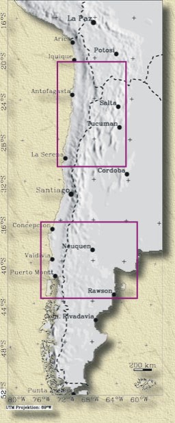
Fig. 1: Working area of project F4
Abstract
We are integrating multidisciplinary studies to further our understanding of the structure, composition and rheology of the upper plate along the Southern Andean active margin. We will focus on:
-
a northern study area ("Northern Area" between 20° and 30°S) with significant topographic relief, crustal thickening and evidence for the evolution of a high plateau, and
-
a contrasting southern study area ("Southern Area" between 37° and 42°S) with thinned crust, a mostly extensional tectonic history and relatively subdued topography.
Our aim is to conduct integrated modeling of the factors controlling the evolution of the upper plate at different scales in these two contrasting regions. The key controlling factors that we will test are:
-
Rigidity and large-scale viscosity of the Andean lithosphere by modeling the geoid, the isostatic gravity field and its gradients;
-
Stress distribution and buoyancy forces from 3D density and load modeling;
-
Approximate temperature distribution by determining the Curie depth from magnetic field observations.
Working towards these aims will involve re-modeling of lithospheric structures based on petrological, tectonic and geophysical constraints.
Modeling of regional potential field data (gravity and magnetic) over broad areas will provide new insight into the large-scale distribution of controlling parameters (density, magnetic susceptibility, rigidity, stress and Curie depth). Our studies will also focus on segmentation of the active continental margin. Smaller-scale density modeling will also provide local structural information that will allow us to detect similarities and differences between the deeper parts of the volcanic arcs and sedimentary basins of the Southern Altiplano, the Salars of Atacama, Arizaro and Pipanaco in the north, and the Neuquen basin in the Southern Area.
The principal tasks of our small-scale studies are: (a) to develop sequential restorations of the crust and topography, for several time steps from the Neogene to present, constrained by upper-crustal structural geology, sedimentological evidence of paleo-slope directions and volcanic history, (b) for each step to determine the incremental mass balance changes that would have affected the Central Andean Gravity High, and (c) to place the evolution of the Atacama anomaly in the context of the regional magmatic evolution and deformation of the Central Andes.
Objectives, methods, work plan, and schedule
Objectives
We will conduct integrated multidisciplinary modeling of the factors that control the evolution of the upper plate at different scales in two contrasting regions. Regionally, we will focus on:
- a northern study area ("Northern Area" between 20° and 30°S) with significant topographic relief, crustal thickening and evidence for the evolution of a high plateau, and
- a contrasting southern study area ("Southern Area" between 37° and 42°S) with thinned crust, a mostly extensional tectonic history and relatively subdued topography.
The controlling factors that we will examine are:
- Rigidity and large-scale viscosity variations of the Andean lithosphere from modeling of the isostatic gravity field and the geoid,
- Stress distribution and buoyancy forces from 3D density and load modeling and
- Approximate temperature distribution by determining the Curie depth.
We will start by updating our existing models of lithospheric structures using new petrological, tectonic and geophysical constraints. At a regional scale, we have identified five key topics, as outlined below.
- (a) Re-modeling of 3D-density distribution to take into account newly received data and information on structure, tectonics and petrology obtained by team leaders. Modeling will include the entire orogen, from fore- to back-arc, for the complete spectrum of potential field data (geoid, gravity and magnetic fields, and their gradients). We will be able to use the 3D models of density and susceptibility, together with statistical methods, to identify segmentation of the active margin in both N–S and E–W directions. For the ocean-land transition, new data are necessary to complete this analysis. Therefore, the project team will participate in an airbourne gravity and magnetic campaign which will bring together participants from GFZ, FUB and BGR in the framework of the "Geotechnologie Programm" (Geo-Technology Program) and the SPOC experiment on- and offshore Southern Chile.
- (b) For the first time, calculation of a geoid for the entire Central Andes based on our own gravity database, the results of which we will use in the course of 3D density modeling.
- (c) Merging results of tasks (a) and (b) with those from other subprojects (e.g. F1, F3, G1, and G4) and visualization of lithospheric 3D-density/susceptibility models which are constrained by geological and petrological data.
- This integration of results will allow investigation of the influence of the Nazca plate-age on structure, density and susceptibility, and in turn, provide new information on the presently poorly understood isostatic behavior (balancing) of the ocean–crust transition. Consequently, we must compare our density models in the Northern and Southern Areas: the first contains an old and cold oceanic plate, the latter a young and warm plate. Additionally, this study also has to clarify the observation that the volcanic chain in the north is characterized by very strong negative anomalies in the isostatic residual field, while in the south, the volcanic arc is associated with an area of positive gravity field residuals. Is this difference related to significantly younger TDM-model ages in the south? If so, we should observe indicators of differing crustal chemical composition.
- (d) The results of 3D modeling in tasks (a) through (c) are necessary to calculate the flexural rigidity based on model loads. A major part of our study is concerned with the physical relationship between flexural rigidity and lithospheric viscosity, if there is any. Lithospheric rigidity will be used to determine viscosity and the results compared to those from subprojects F1, F2, F3 and G2 (although we acknowledge that "viscosity" will be investigated in each of these sub-projects at different time scales in different large spatial domains). Additionally, variations of rigidity and effective elastic thickness of the lithosphere will also contribute to its spatial segmentation. With the calculated rigidity we will be able to provide first-order constraints on temperature and tectonic style at a regional scale. Stress responds to high topography and crustal density distribution, and this response will be investigated using density models under the assumption that mechanical properties (e.g. Youngs-modulus, Poisson ratio) are known. Stresses will be calculated by H.-J. Götze in subproject F1 (N. Kukowski et al.). We will compare our results with those of the seismic project (G3) and modeling project (G2). We hope to define a 3D distribution of viscosity which is typical for the Andes and to compare this distribution with results from other orogens (e.g. Alps, Cascade subduction zone). Calculations at the western continental margin of the US (Cascade subduction zone) seem to indicate that viscosity distribution can distinguish between domains of compression and dilation.
- (e) Based on the application of Fast Fourier Transformation techniques (FFT), we will use a method that was introduced by R. Blakely (USGS) to calculate variations of the Curie depth in the Northern and Southern Areas (by H.-J. Götze and G. Franz).
Due to the broad spatial coverage of the models to be developed, the objectives in (a) through (e) are concerned with the large-scale distribution of the controlling parameters (rigidity, viscosity, temperature, density and susceptibility). However, there are also problems which will be solved at a more local scale. For example:
- (f) Calculation of loads, the isostatic state and the influence of buoyancy forces in the area of the volcanic arc (H.-J. Götze/G. Franz) in close cooperation with subproject F1 (Kukowski et al.).
- (g) Forward modeling of the deeper structure of the sedimentary basins (Salars of Atacama, Arizaro and Pipanaco), in cooperation with subproject G6 and the Neuquen basin, to detect similarities and differences between them. Equally worthy of study is the question of which process has triggered the combination of extraordinary gravity highs (e.g. CAGH, the Central Andean Gravity High) and the topographic lows (Atacama, Arizaro etc.) in the Northern Area. Did a huge positive mass contrast start sinking as a consequence of dilatation, or was it crustal dilation that allowed intrusion of dense material from below?
Smaller-scale phenomena will be studied in three regions:
- (1) In the area of the CAGH (Northern Area). This study is planned as a combined effort with a Cornell University Group headed by T. Jordan. Principal tasks are: (a) to develop sequential restorations of the crust and topography, constrained by upper-crustal structural geology, sedimentological evidence of paleo-slope directions, and volcanic history for several time steps in the Neogene; (b) for each step, to determine the increment of mass excess (or deficit) that would have been added to the CAGH to explain the topographic evolution; and (c) to place the evolution of the Atacama anomaly in the context of the regional magmatic and deformation history of the Central Andes.
- (2) In the southern Altiplano and northern Puna (closely related to subproject G6, Strecker et al.) we will model and visualize the structure and position of the Kenyani lineament and its expression in gravity anomaly images (together with subproject G7, Scheuber). This density modeling will also provide information on the extension of the "Andean batholith" proposed by Chmielowski et al. (1999). However, due to a lack of gravity data, to address this problem we must first make new gravity observations in the Eastern Altiplano/Eastern Cordillera.
- (3) 3D-Modeling of the Neuquen basin will provide information on its westward extension and contribute to discussions on the "backarc" versus "intra-continental" origin for this basin. This part of our project will be carried out by all team leaders as well as T. Jordan and V. Ramos. We have agreed to model a rather complete section which will include the Principal Cordillera, the magmatic arc with the Liquiñe - Ofqui fault and the basin.
Data acquisition (Altiplano/Eastern Cordillera):
To support the 3D models of the Eastern Altiplano region, we need new gravity data. These new data will be recorded during a small field campaign in the first year (by 2 participants from FUB for 3 weeks). We are planning to observe approx. 200 stations. These new stations will supplement the existing network of gravity sites, and will allow modeling on the basis of measured data and not on interpolated anomalies that result from the large gaps in the Bolivian gravity network. The area of the proposed field campaign is evident in the figure below.
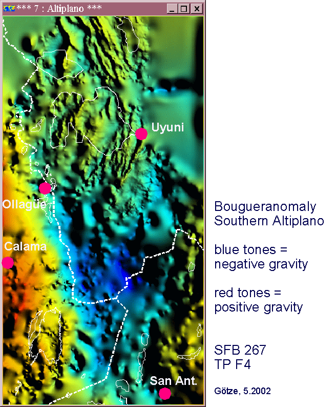
Fig. 2: Figure 2 showing the shaded Bouguer gravity field in the area of the Southern Altiplano/Northern Argentinean Puna. The image is based on a dataset of 15,000 gravity stations (subproject F4 and partners). The image emphasizes the strong gravity gradients in regions with excellent data coverage and the poor results in areas with few data, such as east of Uyuni. This is the area of the proposed short field campaign. White dotted lines show international borders, thin white lines mark the shorelines of salars (salt lakes).
Data acquisition (Principal Cordillera):
A large gap in our data still exists in the volcanic arc on the Chilean side of the Southern Area. Data are needed for density/susceptibility models that will show the western rim of the Neuquen basin. The project team will ask Dr. M. Araneda to do this field work together with participants from Chile (Santiago and/or Concepción). The results of this campaign will be available immediately because our SFB software will be used for processing.
Aerogravity and aeromagnetics
This campaign is planned for 2002 and will help to link land-based data and satellite gravity data. This program is funded outside the SFB by the "Geo-technology Program" and local partners. The aerogeophysics campaign is part of a bigger project which also includes investigations by Germany's research vessel SONNE. The project team's participation in the SPOC initiative will contribute to tasks (a), (b) and (c) above. All teams are also are cooperating with colleagues from the BGR in Hannover.
Methods
3D forward modeling and inversion (density and susceptibility) will be conducted using FFT and non-linear inversion techniques that are incorporated in our 3D modeling program IGMAS (Interactive Gravity and Magnetic Application System). An important step for stress calculations is the calculation of model loads at different depths within the IGMAS density models. Results of the Andean geoid determination will also be interpreted using forward modeling (with IGMAS and IVIS 3D) of the three gravity components. This includes the calculation of the plumb lines gx and gy which will be useful for identifying regional segmentation of the continental margin. Our last gravity field campaign, in the year 2000, has provided land-based gravity data from the active Pacific margin to the passive Atlantic margin. Before re-modeling, these data will be merged, using our own software, with satellite (CHAMP mission) and ship-borne (SONNE cruises) data.
Modeling of mass and volumes (e.g. in the magmatic arc) will be performed directly by a special subroutine in the forward modeling software IGMAS. By combining petrological constraints and numerical results derived by applying the theorems of Gauss and Green to isostatic anomalies, we hope to give an independent "integral" estimate of the mass and volume of the volcanic arc. We hope to obtain constraints on both physical properties and model geometry from the seismic subprojects (F3 and G3).
We are aiming to better understand the magmatic input into the recent volcanic arc and will compare our results with similar results from seismic studies (G3), magnetotelluric modeling (G4), and those from subproject G5. Interpretation of residual gravity fields computed using different isostatic assumptions show that the position of the recent volcanic arc in the north can be exactly correlated with negative anomalies. This indicates the presence of low density material (magmatic material?). Currently, the sources of these short-wavelength residual gravity anomalies (wavelength < 50 to 80 km) are completely unknown. Results obtained by the Euler deconvolution method point to source depths of between 3 and 15 km.
Modeling of lithospheric loads and stress-components will be separated into local and regional parts: the local stress components are caused by topographic loads and lithospheric density inhomogeneities and these will be modeled by examining coherency/admittance functions between topography and gravity. To determine regional stress, we assume that the subsurface region to be modeled can be divided into several horizontal plates in an elastic half space; this leads to linearization and, therefore, simplification of the numerical problem. The theoretical elastic plates are located on top of a low-viscosity fluid. From the conditions of equilibrium for such a system, shear and vertical stress distribution can be calculated. For this purpose, we have developed our own algorithms which operate in the wavenumber domain using FFT techniques. They are fast and robust, and enable testing of a large number of different models. These results will serve as important data input for subproject F1 and will be tested in subprojects F2 and G1.
Temperature modeling from magnetic data will utilize the strongly magnetic oceanic and continental crust in this region. This strong magnetization is the result of large volumes of basaltic material with its characteristically high magnetic susceptibility. Different polarities of the Earth's magnetic field vector cause the well known linear features in the present-day field. Additionally we know that viscous NRM changes anomalies constantly by the influence of changes in temperature. The method to be used here is based on an analysis of the magnetic field in the frequency domain (Blakely, 1988). This method can provide regional knowledge of average temperature at depth. The method can also help to estimate the depth of magnetic sources from the statistical properties of magnetic anomalies, and it will be applied to a compilation of satellite and aeromagnetic data from the Andes. Correlation with published heat flow measurements (G4 and G1) is apparent and suggests that undulations in basal depths of magnetic sources are related in part to undulations in the Curie temperature isotherm.
However, the anomalies discussed above never disappear directly in the trench, but rather in a position where the downgoing oceanic plate passes the depth of the Curie temperature isotherm. This position depends on the temperature (age) of the plate, the subduction angle, the velocity of the subduction and the content of magnetic minerals. We expect to be able to observe these changes in the Earth's magnetic field along the South American active margin by analyzing satellite, ship-borne and aeromagnetic field data (using forward modeling and bi-dimensional statistics). This will allow the division of both the Nazca plate and the forearc region into distinct parts that can then be interpreted as the result of regional changes in the subduction scenario in response to thermodynamics and tectonics.
Methods to be used for gravity field campaigns and data processing
All gravity observations will be made along passable tracks and roads that allow sufficient coverage of the areas of interest. Heights will be determined from Differential GPS measurements at each gravity site. The gravity field processing will be undertaken following our own standards which include "station complete" Bouguer anomalies, free-air anomalies and isostatic residuals. The magnetic field observed by the CHAMP mission will be processed in the GFZ.
Work Plan and Schedule
1st year (2002)
3D re-modeling:
Data collection and adjustment for geoid calculation; collation of model constraints from petrology, seismology, tectonics and magnetotellurics, commence updating regional density/susceptibility models.
Staff, SFB cooperation and invited guests:
All team leaders, R. Hackney, F. Lucassen, Z. Tasárová and students, visit Prof. Meurers (Vienna); G4 Brasse and Haak; F2 (Klotz); F3 (Shapiro et al.); G2 (Handy et al.). Our modeling results will be provided to other subprojects, e.g. F1 (Kukowski et al.), G1 (Franz, Sobolev and Romer).
3D modeling of basins:
Preparation of model input, design of a starting model for Salar de Atacama.
Staff, SFB cooperation and invited guests:
H.-J. Götze and R. Hackney, together with T. Jordan (Cornell Univ.). SFB cooperation with G6 (Strecker et al.), G7 (Scheuber).
Petrological and geological data acquisition:
Petrological field and laboratory work (analysis of rock samples for density and composition).
Staff, SFB cooperation and invited guests:
Team leaders G. Franz, H. Echtler and F. Lucassen, together with Prof. Hervé (Santiago) and colleagues from research group of Prof. Figueroa, Concepción (Chile); G5 (Huenges et al.), G1 (Franz et al.).
Data acquisition, field campaigns:
Preparation and completion of aero-gravity campaign covering the Southern Area.
Staff, SFB cooperation and invited guests:
Team leaders (U. Meyer and H.-J. Götze), D. Marchenko and student GFZ; 1 person for a preparatory flight to Chile, visit of Prof. Forsberg (Copenhagen) for geoid modeling and preparation of campaign.
Processing of data from aerogeophysics campaign, gravity campaign, CHAMP, Araneda data; merging of all data sets and update of potential field database.
Staff, SFB cooperation and invited guests:
Team leaders (U. Meyer and H.-J. Götze), R. Hackney, Z. Tasárová and D. Marchenko; students at FUB and GFZ, together with Prof. Meurers (Vienna); and Prof. Yañez (Santiago), also together with F2 (Klotz).
Preparation and completion of short gravity campaign (Altiplano/East Cordillera).
Staff, SFB cooperation and invited guests:
2 persons of FUB team and 1 person from La Paz.
Data acquisition in the Principal Cordillera: gravity campaign by Dr. M. Araneda (Santiago, Chile).
Staff, SFB cooperation and invited guests:
Organization/coordination: H.-J. Götze and R. Hackney FUB.
Petrological sampling in the Southern Area (with U de Concepción, Chile).
Staff, SFB cooperation and invited guests:
1 member of TUB team with 1 person from U de Concepción.
Model update, visualization and merging information:
All team leaders, F. Lucassen, R. Hackney, Z. Tasárová and D. Marchenko, G4 Brasse and Haak; F2 (Klotz); F3 (Shapiro et al.); G2 (Handy et al.); Modeling results will be provided to other subprojects, e.g. F1 (Kukowski et al.), G1 (Franz, Sobolev and Romer).
Presentation and publication:
Participation and presentation of results at AGU to be held in San Francisco (USA).
Staff, SFB cooperation and invited guests:
3 participants of project team.
2nd year (2003)
Geoid modeling:
Staff, SFB cooperation and invited guests:
Team leader U. Meyer, D. Marchenko. Cooperation with F2 (Klotz)
3D re-modeling:
Final update of potential field database.
Staff, SFB cooperation and invited guests:
R. Hackney, Z. Tasárová and D. Marchenko, students at FUB and GFZ. Database provided to subproject Z.
Continuation of regional 3D density and susceptibility modeling, Curie depth modeling, FFT, statistics, rigidity calculations; relationship between rigidity and viscosity.
Staff, SFB cooperation and invited guests:
All team leaders with Prof. Ramos (Buenos Aires), R. Hackney and F. Lucassen, Z. Tasárová, student at FUB. Close cooperation with F1 (Kukoswki et al.); F3 (Shapiro et al.) and G1 (Franz, Sobolev, Förster). For the interpretation of our modeling results we also need observations and results from modeling the history and evolution of the high plateau from subproject G6 (Strecker et al.). Also, data and information exchange with G2 (Handy et al.) and G4 (Brasse and Haak).
3D modeling of basins:
Continuation of modeling of local density model in the area of the CAGH, modeling of the area of the Southern Altiplano.
Staff, SFB cooperation and invited guests:
H.-J.Götze, G. Franz and H. Echtler with Prof. Jordan (Cornell Univ.) and Prof. Ramos (Univ. Buenos Aires), R. Hackney, F. Lucassen, Z. Tasárová, student at FUB. Cooperation with G6 (Strecker et al.), G7 (Scheuber), G8 (Heubeck).
Data acquisition:
Data acquisition Principal Cordillera: gravity campaign by Dr. M. Araneda.
Staff, SFB cooperation and invited guests:
Organization: R. Hackney.
Petrological laboratory work (analysis of rock samples for density and composition)
Staff, SFB cooperation and invited guests:
G. Franz and F. Lucassen together with colleagues from research group of Prof. Figueroa Concepción (Chile).
Model update, visualization and merging information:
All team leaders, F. Lucassen, R. Hackney, Z. Tasárová and D. Marchenko; G4 (Brasse and Haak); F2 (Klotz); F3 (Shapiro et al.); G3 (Shapiro), Z (Munier et al.).
Modeling results will be provided to other subprojects, e.g. F1 (Kukowski et al.), G1 (Franz, Sobolev and Förster).
Presentation and publication:
Presentation of results at IUGG to be held in Sapporo (Japan) and AGU (San Francisco); publication of new data sets together with a preliminary interpretation of the potential field database.
Staff, SFB cooperation and invited guests:
All team leaders, R. Hackney and F. Lucassen, Z. Tasárová and D. Marchenko.
Congresses: 3 participants of project team for each congress.
3rd year (2004)
3D re-modeling
Continued modification and updating of regional density and susceptibility models, as well as Curie depth modeling, FFT, statistics, geoid, flexural rigidity and viscosity modeling. Modeling of the volcanic arc together with stress distribution in association with F1 (Kukowski et al.) and Prof. G. Yañez.
Staff, SFB cooperation and invited guests:
H.-J. Götze and U. Meyer, R. Hackney, F. Lucassen, Z. Tasárová and D. Marchenko, data exchange and knowledge transfer: G3 (Kind, Asch, Wigger), G4 (Brasse and Haak) and G1 (Franz, Sobolev and Romer), F2 (J. Klotz), F3 (Shapiro et al.), G2 (M. Handy), F1 (Kukowski) and F3 (Shapiro).
3D modeling of basins:
Continued modeling of local density structure in the area of the CAGH, modeling of the area of the Southern Altiplano and Neuquen basin.
Staff, SFB cooperation and invited guests:
H.-J. Götze with Prof. Jordan, Prof. Ramos, Z. Tasárová, student at FUB. Data exchange and knowledge transfer: G4 (Brasse and Haak), cooperation with G6 (Strecker et al.), G7 (Scheuber), G8 (Heubeck).
Model update, visualization and merging of information:
All team leaders, F. Lucassen, R. Hackney, Z. Tasárová and D. Marchenko, Data exchange and knowledge transfer: G4 Brasse and Haak; F2 (Klotz); F3 (Shapiro et al.); G2 (Handy et al.), F1 (Kukowski et al.), G1 (Franz, Sobolev and Romer).
Presentation and publication:
Presentation of results at IUGS in Florence (Italy) and AGU (San Francisco)
Staff, SFB cooperation and invited guests:
3 participants of project team for each congress.
Publication of new data sets together with interpretations.
Staff, SFB cooperation and invited guests:
All team leaders, R. Hackney and F. Lucassen, Z. Tasárová and D. Marchenko.
Collaboration with external research groups
Names of important partners in the host countries
Chile:
-
Prof. Dr. G. Yañez, CODELCO, Santiago.
-
Dr. C. Mpodozis, SIPETROL S.A., Santiago.
-
Prof. Dr. G. Chong, Antofagasta.
-
Prof. Dr. G. Alfaro, Prof. Dr. K. Bataille, and Prof. Dr. O. Figueroa, Concepción.
-
Dr. M. Araneda und Lic. Geof. M. Avendaño, SEGMI, Santiago.
Argentina:
-
Prof. Dr. V. Ramos, U de Buenos Aires.
-
Prof. Dr. R.Omarini, UNSa, Salta.
-
Dr. R. Hechem, Repsol-YPF, Neuquén.
-
Dr. P. Kress, Repsol-YPF, Buenos Aires.
-
Prof. Dr. J. Kostadinoff, Prof. Dr. Llambias, UN de Bahia Blanca.
Bolivia:
-
Ing. Claure Z., Dr. S. Tawackoli, SERGEOMIN, La Paz.
Collaboration with national and international research groups external of SFB
-
On December 1, 2000 a project was issued by NSF to Prof. Dr. T. Jordan (Cornell University, N.Y.) which is closely related to some of the tasks of our SFB project. It is entitled "Neogene Evolution and Significance of the Atacama Basin Topographic Anomaly, Andean Forearc of northern Chile" and was issued in collaboration with B.L. Isacks, R. Allmendinger (both at Cornell University), C. Mpodozis (SIPETROL, Santiago) and H.-J. Götze (FU Berlin). This project is fully integrated with ongoing projects of Chilean, US and German colleagues. The principal tasks are: (1) to develop sequential restorations of the crust and topography for several time steps in the Neogene, based on constraints from upper-crustal structural geology, sedimentological evidence for paleo-slope directions, and volcanic history, (2) for each step, to determine the increment of mass excess (or deficit) that would have been added to the CAGH to explain the topographic evolution, and (3) to place the evolution of the Atacama anomaly in the context of the regional magmatic and deformation history of the Central Andes.
-
MSc. A. Tassara (Universidad de Chile, Depto. de Geología) has been granted a 3-year scholarship from the Deutscher Akademischer Austauschdienst (DAAD). He will spend the entire time at FU Berlin working in the research group of H.-J. Götze and in close cooperation with the proposed SFB 267 subprojects F4 and F1 (Kukowski et al.).
-
Geodetical Survey of Denmark (KMS), Copenhagen: Prof. Dr. R. Forsberg und Dr. G. Strykowski, determination of a South American geoid and cooperation related to aero-gravity campaign.
Publications
Literature
Reviewed publications
Breunig, M., Cremers, A.B., Götze, H.J. Seidemann, R., Schmidt, S., Shumilov, S. and Sight, A. (1999): Geologische Kartierung mit GIS auf der Grundlage von 3D-Modellen. - 13th International Symposium on Environmental Information Systems' Umwelt-Informatik aktuell,, 23: 417- 428; Magdeburg. - []
Götze, H.-J. and S. Krause (2002): The Central Andean Gravity High, arelic of an old subduction complex?. - Journal of South American Earth Sciences, 14 (8): 799 - 811.
Götze, H.-J. and S. Schmidt (2000): Rigidity of the Central Andes and their isostatic state by density modelling.. - IX Congreso Geologico, : ; Puerto Wares (Chile),. - []
Li, X. and H.-J. Götze (2001): Ellipsoid, geoid, gravity, geodesy and geophysics - a tutorial. - Geophysics, 66 (6): 1660-1668. - []
Li, X. and H.-J. Götze, (1998): Comparison of some gridding methods. - 68th Annual Internat. Mtg., Soc. Expl. Geophys.: p. 537-539. - []
Li, X. and H.-J. Götze, (1999): Comparison of some gridding methods.. - The Leading Edge, Vol. 18, No. 8: 898-900. - []
Omarini, R., H.J. Götze, R.J. Sureda, A. Seilacher and F. Pflüger (1999): Puncoviscana folded belt in NW Argentina: testimony of Late Proterozoic Rodinia fragmentation and pre- Gondwana collisopnal episodes. - Geologische Rundschau, Vol. 88, No. 1: 76-97; . - []
Romanyuk, T., H.J. Götze and P.F. Halvorson (1999): A density model of the Andean subduction zone. - The Leading Edge, vol. 18, no. 2,: p.264-268; . - []