


Subproject G3: Seismological image of lithospheric deformation in the Central Andes
Research Field: Geophysics, Seismology
-
Research staff
-
Working area
-
Abstract
-
Objectives, methods, work plan, and schedule
-
Collaboration with external research groups
-
Publications
Staff
Project-Leader(s)
Co-Leader(s)
Working area of the subproject G3
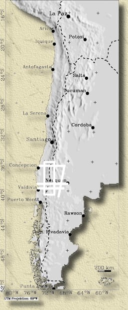
Fig. 1: Working area of project G3
Abstract
Previous investigations within the SFB have opened new geophysical methods of imaging deep structures in the crust and the mantle. The first application of these methods has led to new insights into the different modes of shortening in the Central Andes, in a seismic follow-up receiver function experiment we will be able to explain the shortening mechanisms in the central Andes. We will clarify in detail the style of crustal shortening in the eastern Altiplano by identifying the progression of the surface thrust faults of the eastern Cordillera into the lower crust. In the subduction zone, we will be able to identify the location of the subducting crust, which will enable us to test opposing petrological hypotheses which place seismicity alternatively above or below the subducting oceanic crust. In the Puna region we will be able to supplement known non-geophysical indications of mantle delamination with decisive geophysical information, as was already done in Tibet.
Objectives, methods, work plan, and schedule
Aims of the proposal
Very interesting results have been obtained in the previous applications of the receiver function method within the SFB. These results represent essential contributions to problems of the origin of the Andean plateau. We repeat these results here because some of them are the base for this proposal
-
The detection of an extended zone of partial melt in the upper crust below the Altiplano and Puna plateaus, leading to their flat topography.
-
The generation of a Moho map in the entire region. A shallow Moho was detected underneath the Puna, suggesting (together with tomographic indications by Schurr 2000) delamination as mode of lithospheric thinning there.
-
The production of a high resolution image of the subducting oceanic crust down to 120 km depth, providing (together with the end of the seismicity at the same depth) a geophysical confirmation of the gabbro-eclogite phase transformation hypothesis.
-
Confirmation by receiver functions of a west-dipping structure in the crustal interior, which was detected by earlier refraction experiments (Wigger et al.1994), and which may be indicative of the mode of crustal shortening there.
We propose follow-up experiments to solve the questions raised by the earlier experiments, because we think we can solve with these especially designed experiments essential questions concerning the modes of lithospheric shortening in the central Andes. We plan a passive source experiment across the entire Andes from the subduction zone in the west to the west-dipping inner crustal structure proposed under the eastern Altiplano along 21?S. About 60 stations will be deployed along this profile for about two years. Experiences with earlier experiments have shown that such a long recording period is necessary because a sufficient number of high quality earthquakes must be recorded. A second, shorter profile is proposed in the Puna to study the proposed delamination process there (see Fig.2). Below we describe in more detail the problems we can solve and how we intend to do this:
1) Modes of crustal shortening in the eastern Altiplano
In the eastern part of the receiver function profile along 21?S we expect to image the supposed inner crustal discontinuity in such great detail, that we can solve the question of the main mode of crustal underthrusting. Does this discontinuity penetrate the entire crust to the Moho or even deeper, does it flatten towards the west without penetrating into the lowermost crust, or does it disappear towards the west? Each one of these structures would indicate a different mode of crustal thickening. Another important question is the waveform of the converted waves. Complexity of these waveforms would indicate complexity of the shear zone, which should be symptomatic for raising fluids or melts within the shear zone, possibly hinting at their fundamental role in localizing shear in the thick, plateau-style crust.
2) Relation between earthquakes and the subducting oceanic crust
The main question in the western part of the profile along 21?S is the exact location of the subducted oceanic crust in the mantle. The boundaries of the crust are defined by the oceanic Moho and the transition to the continental mantle. Yuan et al (2000) have shown that this can be determined by averaging all data over several hundred kilometres in north-south direction. With such a narrow and dense profile along 21?S, we will form this image with much higher resolution because we will not need to average. Earthquake locations are available from the passive ANCORP project (and will be improved by TP F3 within this proposal), and in addition we have the active ANCORP reflector from the serpentinization front. The combination of such very different datasets has never (and nowhere) been attempted, and we are very optimistic about the expected results. By determining the exact location of the slab earthquakes relative to the subducted crust we (in cooperation with TP F3) will be able to narrow down the possible causes for these earthquakes and test competing hypotheses. The hypothesis of Schilling at al. (2000) predicts earthquakes up to perhaps 30 km inside the continental mantle due to dewatering of serpentine, while the hypothesis of Karato et al. (2001) predicts earthquakes in the oceanic mantle due to ductile faulting caused by temperature gradients.
3) Detachment of the lower lithosphere below the Puna
The main target of our search with the profile in the southern Puna (see Fig.2) is geophysical evidence for the existence of mantle delamination. Signs of delamination in this region are so far mainly non-geophysical (geochemical composition of melts). There is as of yet no direct image of the delamination process, with the exception of some indication in seismic tomography images obtained by Schurr (2000). Kosarev et al. (mainly SFB members, 1999) have shown in Tibet that the receiver function technique is able to image delamination in the mantle. The same technique is proposed for the Puna.
4) Additional aims
The data obtained in the proposed experiment will also be used in additional techniques to image the structural effects of the ongoing processes. Teleseismic tomography will be used to generate a 2D cross section along the profile. The obtained model of the velocity variations will also be used for receiver function migration. The two-year recording period will provide a suitable data set for a high resolution image. This is will complement the proposed receiver functions and will allow the retrieval of information on the deeper structures not covered by ray paths of local earthquakes. New software developments in event detection make it possible to evaluate the existing ANCORP 96 and PUNA 97 local earthquake data sets with higher accuracy. This will allow us to image the southern part of the Altiplano, from which only a 2D tomographic section exists (Schurr 2000), with higher resolution. The same improved software allows the identification of onsets of weak and shallow earthquakes in the raw data files. This makes searching for crustal events more effective. The crustal seismicity will yield additional constraints for the interpretation of crustal receiver function results and will help to constrain the style of ongoing crustal deformation.
Work plan and schedule
We plan to install and operate about 60 seismic stations along 21?S for a two years period as shown in the attached map (Fig.2). The 60 stations will be installed on a profile of about 500 km length, and they will be operated at a rate of 50 samples per second, which also permits recording of local earthquakes and quarry blasts. Storage capacity is sufficient for about one year of continuously recording three channels; however, to check instrument performance, the stations should be visited once every 4-5 months and the data should be retrieved. Data processing can thus be done between visits. The stations will also record local earthquakes and the signals of the big explosions from the great copper mines situated on the forearc at different latitudes in Chile. These data from daily shots from the mines (Cerro Colorado, Quebrada Blanca, Collahuasi, El Abra, Chuquicamata, Zalvidar, La Escondida) over a two year time span can be stacked and used for a 2.5-D tomography to improve the velocity model of the crust; only a reference time break recording inside the mines is needed for the use of this data. After one year of recording, we expect to find enough suitable events to identify the Andean shear zones and their extension to the west. Based on this information, the profile will be condensed in the area of interest, to achieve a higher resolution. The long recording period of two years is necessary to insure recording of a sufficient number of earthquakes for high quality results.
In addition, a shorter profile consisting of 10 stations is proposed at 26?S to investigate lithospheric delamination (Fig.2). It will cross the Cerro Galan, one of the prominent intra plate volcanoes which erupted during the youngest period (2Ma to present) and which might be related to delamination. A total of 70 stations is requested from the geophysical equipment pool of GFZ. Not all of them can be broadband stations, because there are not enough broadband seismometers available. We hope to equip 50% of the stations with broadband sensors; the remaining will operate with short period sensors. We think, however, that we can reconstract relative broadband data also from the short period records (Yuan et al.1997). During the visits to the field stations every 4-5 months, discs will be exchanged, and stations will be checked and repaired if necessary. The data will be copied from the discs to tapes in the field, and the tapes will be taken to Potsdam. In Potsdam the tapes will be fed into the GEOFON archive. GEOFON is a permanent network of about 40 globally distributed stations which is archiving all these data and offers via internet free access to the data to everyone. That means archiving is a routine operation at Potsdam, and the Andean data will be treated exactly as other data of the GEOFON network. This ensures rapid and reliable archiving. Archiving will be finished a very short time after the field experiment is finished and the data will be accessible to every SFB member; the data will be accessible to other scientists two years after the end of the experiment. This rapid archiving system makes it possible, in between field trips, to start with such data processing as selection of useful events and first interpretation. Archiving and processing of data from 70 stations sampled with 50 Hz over a period of two years is no easy task. However, with the requested personnel and thanks to the existing GEOFON archiving system, it can be done. The data of most other GFZ field experiments are archived the same way. Software for interpretation is available. An experienced Postdoc with some help should be able to do this work, and the data processing will be nearly finished by the end of the field campaign. The third year should be sufficient for the interpretation of data and for the publication of results.
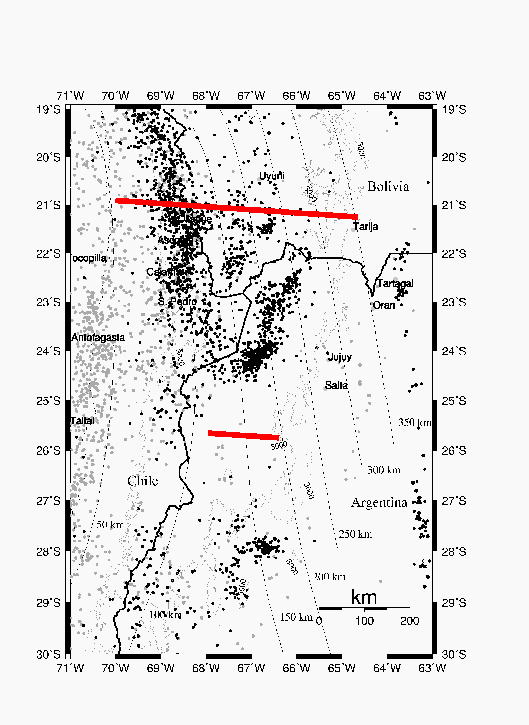
Fig. 2: Proposed receiver function profiles at 21?S (Altiplano) and 26?S (Puna). Earthquakes (grey < 80km < black) are from the PDE catalogue; isolines of the Benjoff plane after Cahil & Isacks (1992)
Collaboration with external research groups
Names of important partners in the host countries
Argentina:
-
J. Viramonte, Univ. Salta
Chile:
-
D. Comte, Univ. de Chile, Santiago
-
M. Pardo, Univ. de Chile, Santiago
-
K. Bataille, Univ. Conception, Conception
Bolivia:
-
R. Ayala, Obs. San Calixto, La Paz
Publications
Posters
The SFB 267 poster index is available on the poster page
Literature
Reviewed publications
Bock, G., B. Schurr and G. Asch (2000): High-resolution receiver function image of the oceanic Moho in the subducting Nazca plate. - Science, : ; . - []
Bock, G., Schurr, B. and Asch, G. (2000): High-resolution image of the oceanic Moho in the subbducting Nazca plate fro P-S converted waves. - Geophys. Res. Let., Vol. 227, No. 23: 3929-3932.
Bohm, M., L?th, S., Echtler, H., Asch, G., Bataille, K., Bruhn, C., Rietbrock, A. and Wigger, P. (2002): The Southern Andes between 36? and 40?S latitude: seismicity and average seismic velocities. - Tectonophysics, 356 (4): 275-289.
Chmielowski, J., Zandt, G., and Haberland, Ch. (1999): The Central Andean Altiplano-Puna Magma Body.. - GRL, 26(6): 783-786.
Estabrook, Ch. H. (1999): Body wave inversion of the 1970 and 1963 South American large deep-focus earthquakes. - J. Geophys. Res., Vol. 104, No. B12: 28.751- 28.767; . - []
Giese, P., Asch,G., Brasse, H., G?tze, H.-J., Haberland, C. & Wigger, P. (1999): Procesos Geodinamicos en los Andes Centrales, representados mediante observaciones geofisicas.. - Geologia del Noroeste Argentino, Tomo I: 15-17; Salta.
Giese, P., K.J. Reutter, E. Scheuber (1998): Welche Prozesse haben die Entstehung der extremen Dimension der zentralen Anden verursacht?. - , in Vorbereitung.
Giese, P., Scheuber, E., Schilling, F., Schmitz, M. & Wigger, P. (1999): Crustal thickening processes in the Central Andes and the different natures of the Moho-discontinuity.. - J. of South American Earth Sciences, 12: 201-220.
Graeber F.M., G. Asch (1999): Three-dimensional models of P-wave velocity and P-to-S velocity ratio in the central Andes by simultaneous inversion of local earthquake data. - Journal of Geoph. Research, Vol. 104, NO. B9: 20237-20256..
Haschke, M.R. (2002): Evolutionary geochemical patterns of Late cretaceous to Eocene arc magmatic rocks in North Chile: Implications for Archean crustal growth. - EGS Special Book Series, in press.
Kind, R., S.V. Sobolev, X. Yuan, X. Li, J. Gossler and G. Kosarev (2000): Analysis of major global tectonic structures using P-to-S converted seismic waves. - Annali di Geofisica, : ; . - []
Patzig, R.; Shapiro, S.; Asch, G.; Giese, P.; Wigger, P. (2002): Seismogenic plane of the northern Andean Subduction Zone from aftershocks of the Antofagasta (Chile) 1995 earthquake. - DOI 10.1029/2001GL013244. - []
Patzwahl, R., Mechie, J., Schulze, A. und P. Giese (1999): 2-D-velocity Models of the Nazca Plate subduction zone between 19.5?S and 25?S from wide-angle seismic measurements during the CINCA 95 Project. - J. Geophys., Res 104,: 7293-7317..
Schmitz, M., Lessel, K., Giese, P., Wigger, P., Araneda, M., Bribach, J.; Graeber, F., Grunewald, S., Haberland, C., L?th, S., R?wer, P., Ryberg, T. & Schulze, A. (1999): The crustal structure beneath the Central Andean forearc and magmatic arc as derived from seismic studies ? the PISCO 94 experiment in northern Chile (21?-23?S).. - J. South Am. Earth Sciences, 12: 237-260.
Schurr, B., G. Asch, A. Rietbrock, R. Kind, M. Pardo, B. Heit and T. Monfret (1999): Seismicity and Average Velocities beneath the Argentine Puna Plateau. - Geophys. Res. Lett.,, 26, no. 19: 3025- 3028; . - []
Publikationen in Tagungsbänden
Giese, P. (1995): The Central Andes, a Mountain Belt with a tectonic and metasomatized root.. - Supplement No. 1 to TERRA Nova, 7: 277.
Giese, P. (1995): The Central Andes Lithosphere, Thickened by Tectonic and Magmatic/Metamorphic Processes. - International Union of Geodesy and Geophysics (IUGG), General Assembly, Boulder, 2-14.7.1995, Abstracts: A445; Boulder.
Giese, P. (1996): Die Zentralen Anden, ein Orogen mit zwei unterschiedlichen Wurzeln. - Terra Nostra (15. Geowiss. Lateinamerika Koll.), 8/96: 46; Hamburg.
Giese, P. (1996): The interdisciplinary geoscientific research project "Deformation Processes in the Andes".. - 3rd International Symposium on Andean Geodynamics, St. Malo - Frankreich, ORSTOM (eds.): Troisi?me symposium international sur la G?odynamique andine (ISAG), St Malo: 37-38; St. Malo.
Giese, P. (1997): Deformation processes in the Central Andes - new data and new problems. - European Geophysical Society (EGS); Wien.
Giese, P., Scheuber, E., Sobolev, S. (1997): Das Problem der Krustenverdickung in den zentralen Anden. - 57. Jahrestagung der Deutschen Geophysikalischen Gesellschaft, Potsdam, Abstractband AN 15: 84; Potsdam.
Giese, P., Sobolev, S. (1997): How to interpret the thickened crust of the Central Andes?. - EUG 9, Strasbourg, Abstract Supplement No 1, Terra Nova Volume 9, 37/4B30: 339; Strasbourg.