


Subproject F2: Constraints on the viscosity of upper mantle and lower crust and the present-day surface deformation
Research Field: geodesy, numerical modeling, geodynamic, geophysics
-
Research staff
-
Working area
-
Abstract
-
Objectives, methods, work plan, and schedule
-
Collaboration with external research groups
-
Publications
Staff
Project-Leader(s)
Co-Leader(s)
Members
Working area of the subproject F2
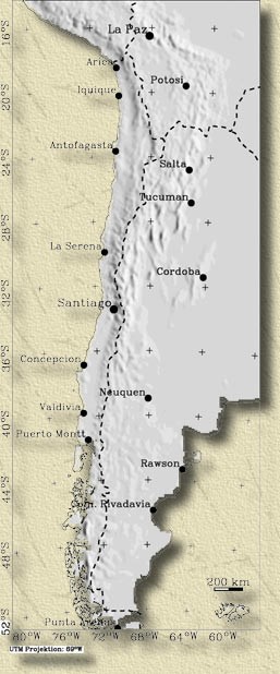
Fig. 1: Working area of project F2
Abstract
One of the main factors controlling the evolution of the Andean orogen is the viscosity of the upper mantle and the lower crust. Constraints on the viscosity of the Earth at these depths can be derived from measurements of crustal deformation that are caused either by postglacial rebound or postseismic relaxation processes. Due to the fact that the 1995 Mw8.0 Antofagasta earthquake occurred after the establishment and measurement of the SAGA GPS network, we are now in possession of a unique dataset of present-day crustal deformation rates that includes postseismic effects following this event. Even more interesting results came from our measurements in the southern part of the SAGA network. The deformation field deduced from the 1994-96 GPS campaigns reveals an obvious postseismic effects of the 1960 Mw9.5 Valdivia earthquake, 35 years after its occurrence. Thus, we have postseismic deformation data from two distant locations along the Andean margin, which should enable us to estimate not only the overall viscoelastic characteristics of the Earth's upper mantle and the lower crust, but also to address the question of its lateral variation. Our objective will be achieved with the aid of two independent modeling approaches. The first approach is based on an analytic formulation which includes a viscoelastic-gravitationally layered Earth. The second approach will be based on numerical methods using a 3-D finite element model. The latter model is a further development of the 3-D elastic dislocation model which we used to explain present-day surface deformation in our previous work. As a result of our proposed research we will be able to provide the first direct estimates of viscoelastic parameters of the upper mantle and the lower crust along the Andean margin.
Objectives, methods, work plan, and schedule
Objectives
The main objective of our proposed work is to constrain the rheological properties of the upper mantle and the lower crust of the Earth based on postseismic deformation rates obtained from Global Positioning System (GPS) measurements along the Andean subduction zone. This objective will be achieved using our unique dataset of present-day crustal deformation measurements, which includes postseismic effects following the 1995 Mw8.0 Antofagasta (between latitudes 22°S and 25°S) and the 1960 Mw9.5 Valdivia earthquakes (between latitudes 37°S and 43°S) (see Figure 1). As our postseismic deformation data come from two locations separated by 1500 km we will be able to estimate not only the overall viscoelastic characteristics of the Earth's upper layers along the Andes, but also to address the issue of lateral variations. In addition, since our GPS measurements were conducted in very different time periods from the occurrence of the studied events, we hope that our proposed work can shed some light on time-dependence of postseismic relaxation effect. We believe that the results of our proposed research not only will be the first estimates of viscoelastic parameters in this study area, but also will have more general impact on the state of our knowledge regarding the dynamics of the lithosphere and asthenosphere.
Methods
Our study will involve modeling the observed postseismic deformation rates of the surface of the Earth using two different methods. The first method follows an analytic formulation initially presented by Rundle (1982) and later developed by Fernandez et al. (1996b; 1996a), which includes viscoelastic-gravitational layered Earth. Our second approach will be based on numerical methods using a 3-D finite element model developed by Wang et al. (2001). To simplify our further discussion, these two models will be referred to as M1 and M2, respectively. We propose the use of two different methods to model the same set of data in the given study because, on one hand, the M1 model is relatively simple and has an analytic solution characterized with very high numerical accuracy (less than 1 % error) (Fernandez and Rundle, 1994). Thus, this model can be very useful for studying the sensitivity of surface deformations to input parameters. That is especially important on the first step of the proposed research. On the other hand, the second method, based on 3-D FEM approach, will enable us to represent the Earth much closer to its reality, including the complicated slab geometry and lithospheric and mantle stratification. The latter factor, as shown for example by Sabadini and Vermeersen (1997), can be very important when modeling postseismic deformations. Overall, using two independent modeling techniques will undoubtedly contribute to the increased confidence in the obtained results. 1st method The derivation of the time-dependent near field displacements for the M1 coupled viscoelastic-gravitational Earth model is based on three main steps: 1) the computation of Green's functions for the elastic-gravitational field equations; 2) the use of correspondence principle that relates viscoelastic-gravitational and the elastic-gravitational solutions to each other, by applying a Laplace transform to the former; 3) the integration of Green's functions over the finite source region. Further detailed mathematical formulation can be found in Fernandez et al. (1996b; 1996a). The main advantage of this model as compared to the earlier viscoelastic models (e.g. Nur and Mavko, 1974; Thatcher and Rundle, 1984) is the inclusion of gravitational forces. Although on short time scales the gravitational forces do not significantly effect the horizontal postseismic deformations observed in the vicinity of an earthquake, on longer time scales the effect of this force becomes more important and can not be ignored (Ma and Kusznir, 1995). Therefore, the inclusion of gravitational forces is important when modeling the postseismic deformations associated with the 1960 Mw9.5 Valdivia earthquake, measured 35 years after its occurrence. The limitations of the M1 model include the representation of the fault plane as a simple rectangular dipping surface and the fact that the sphericity of the Earth is ignored. The first limitation is probably not significant in our case, since the entire fault in the model is located within the upper elastic-gravitational layer that does not extent deeper than 100 km, and the planar geometry of the fault can be justified due to the fact that the subducting Nazca plate does not exhibit significant variations in its dip angle within this depth range (Cahill and Isacks, 1992; Creager et al., 1995). In addition, the predicted surface deformations are more sensitive to the strike and the depth extent of the fault than to the dip (Fernandez et al., 1996b). The second limitation can also be ignored, since the sphericity of the Earth only plays an important role when modeling far-field (> 1000 km) deformation rates (e.g. Piersanti et al., 1995). Since our main goal is to model GPS data from the vicinity of the two earthquakes under consideration, the representation of the Earth as a flat surface can be justified. In any case, the M1 model is especially convenient since the computer code is publically available (Fernandez et al., 1996a; Fernandez et al., 1999), and we have already successfully compiled the program and used it for initial test runs. 2nd method The second method that we intend to use in our proposed work is based on the 3-D finite element model recently developed by Wang et al. (2001) for the Cascadia subduction zone. The schematic representation of the given model is shown in Figure 2 below. The Earth in this model is represented by 30 and 20 km thick elastic continental and oceanic plates, respectively. These layers overlay a viscoelastic half-space with a uniform Young's modulus of 160 GPa and viscosity ?, ranging between 1018 to 1021Pa×s. The entire model has a Poisson's ratio of 0.25. The lower boundary of the model is arbitrarily placed at the depth of 410 km, the depth corresponding to the olivine-spinel phase transition (e.g. Shearer and Flanagan, 1999). Figure 2: Viscoelastic model M2 by Wang et al. (2001). A: Schematic representation of the model setup. B: Finite element grid of the model. Encouragingly, the preliminary results obtained by Wang et al. (2001) for the Cascadia subduction zone show very similar patterns of postseismic deformation as we observed in two locations along the Andean subduction zone. Specifically, the sites in the vicinity of the 1995 Antofagasta and 1960 Valdivia earthquakes located inland exhibit at first glance strange behavior, with velocity vectors oriented opposite to the plate convergence direction. This unusual behavior of the inland sites is surely due to the delayed response of the Earth to the above mentioned large subduction type thrust earthquakes. Both of these events had a thrust type focal mechanism characterized by forward slip on the fault (Barrientos and Ward, 1990; Sobiesak, 2000) which causes an instantaneous seaward stretch of the fore-arc that consequently induces an elastic shear stress downdip from the rupture surface into the mantle wedge (Wang et al., 2001). As the stress relaxes, the viscous deformation takes place, manifested in a delayed response of the Earth surface to the preceding earthquake. Therefore, while the inland sites are trying to catch up with the coseismic slip and move seaward, the thrust interface gets locked (at least partially) immediately after the event which causes the movement of the coastal sites parallel to the plate convergence direction (as would be expected for the interseismic period of earthquake cycle). The numerical computation for the M2 model will be performed using the Finite Element Program Generator developed by the Institute of Mathematics at the Chinese Academy of Sciences (Liang, 1991). The slip on the fault in the model is prescribed using the split-node method of Melosh and Raefsky (1981). The effect of gravity is incorporated using a pre-stress advection term (Peltier, 1974), which numerically works similarly to the Winkler restoring forces, a commonly used method of simulating the gravity effects (e.g. Cohen, 1994). The finite element grid representing a 3-D viscoelastic model of subduction used by Wang et al. (2001) is shown in Figure 2B.
Work plan and schedule
1st year In the first year of our project we will concentrate on modeling the observed postseismic deformation rates using the M1 model. This stage will naturally have to start with finding the best initial parameters that go into the model, often obtained by other geophysical techniques; our collaboration with sub-projects F4, G3 and F3 is of particular importance. Some of these parameters are the same as used in our previous work with elastic dislocation models, for example, the Nazca/South America plate convergence direction (N77°E) and rate (65 mm/yr) estimated by Angermann et al. (1999) and the shallow geometry of the subducting slab. However, unlike the purely elastic models used in our previous work, the proposed viscoelastic models are characterized by time-dependence. The analysis of the data from intermittent GPS campaigns precludes the detection of time-dependent variations in the postseismic relaxation effects. To detect the possibility of such variations, we intend to include in our modeling the time-series from two continuous GPS stations located within the two study areas, specifically in the towns of Puerto Montt (near the epicenter of the 1960 Valdivia earthquake) and in Antofagasta. We hope that the data from these two permanent GPS stations can yield sufficient resolution in the vertical component of deformation (~2 mm/yr), which can be crucial to differentiate between the two possible mechanisms of postseismic deformation (i.e. afterslip vs. relaxation). For the same purposes, we intend to model the vertical deformation rates following the 1960 Valdivia earthquake leveling surveys (Plafker and Savage, 1970; Barrientos et al., 1992). Towards the end of the 1st year we will start working with the Finite element program generator software. The planned visit by Dr. Kelin Wang from the Pacific Geoscience Center in Canada will help us to "jump-start" this process. 2nd year In the second year of our project we will concentrate on modeling the observed postseismic deformation rates using the M2 model by Wang et al.. Since the depth extent of the subducting slab in the M2 model is far deeper (>400 km) than in the M1 model, it is important to constrain the precise geometry of the slab to this depth using various independent geophysical data, especially from sub-projects F3 and G3. For the shallow (< 50 km depth) part of the slab we can rely on the geometry of the fault used in our 3-D elastic dislocation models (Khazaradze et al., 1999). However, some further refinements might still be needed here. We will take into account the new findings regarding the structure of the crust along seismic refraction profile at latitude 39°S found during the ISSA 2000 project (Lueth et al., 2000). For the intermediate (50-100 km) depth ranges, the geometry of the slab can be constrained using the locations of intra-slab earthquakes recorded at global and local seismic arrays (Graeber and Asch, 1999; Husen et al., 1999), as well as from teleseismic receiver function studies (Yuan et al., 2000). The geometry of the deeper parts of the slab (>100 km depth) can be estimated using the hypocentral locations of Wadati-Benioff zone earthquakes occurring within the subducting slab (Cahill and Isacks, 1992; Creager et al., 1995) supplemented by the results of seismic tomography (Engdahl et al., 1995; Masson and Delouis, 1997). Obviously, close cooperation with sub-projects G3 and F3 is essential in order to constrain the geometry of our model. During the second half of the 2nd year we intend to switch towards the more complicated models, in which the crust will include a lower layer with a viscoelastic rheology and the underlying mantle will consist of several viscoelastic layers characterized by changing rheological properties. The need for this step is justified by the recent theoretical work on the influence of lithospheric and mantle stratification on the surface deformations following an earthquake (Sabadini and Vermeersen, 1997; Cesca et al., 2000). Dr. Wolf (one of the co-investigators of the given subproject), experienced with the similar complexities of postglacial rebound studies, will be especially helpful (Wolf and Kaufmann, 2000). Also, this stage of our modeling will require all available information on the rheological properties of the Andean subduction system. 3rd year In the third year of our proposed research we will perform a comprehensive comparison of the results from our two independent modeling approaches (i.e. M1 and M2). At this stage other subprojects within the SFB will also have important new results, and we will concentrate on a joint interpretation, including publications. We will compare our results especially with those of sub-projects F1, F4, G1, G2, G4 and G5.
Collaboration with external research groups
Names of important partners in the host countries
Argentina:
-
R. Perdomo, UN La Plata
-
V. H. Rios, UN Tucuman
-
J. Viramonte, UN Salta
Chile:
-
O. Cifuentes, IGM
-
K. Bataille, Uni Concepcion
-
A. Cecioni, Uni Concepcion
Publications
Posters
The SFB 267 poster index is available on the poster page
Literature
Reviewed publications
Heinze B., Michel G. & Khazaradze G. (2000): Evidence for Prehistoric Intraplate Earthquakes in the Andean Fore Arc. - Contributions to the Workshop on Evaluation of the Potential for large Earthquakes in Present Day low Seismic Activity Regions of Europe, : 77- 78; Han. - []
Khazaradze, G., G.W. Michel, J. Klotz, B. Heinze, and K. Graefe (2000): Changes in Interplate and Intraplate Deformation Along the Central Andean Margin: A GPS and Neotectonic Study. - Geophysical Research Abstracts, EGS 25th General Assembly: 2.
Khazaradze, G., Klotz, J., Angermann, D., Michel, G.W. and Ch. Reigber (1999): 3D Modeling of Inter-seismic Strain Accumulation in the Central and Southern Andes based on GPS Measurements. - EOS, Trans. AGU, 80: 46.
Khazaradze, G., Klotz, J., Angermann, D., Michel, G.W., Reigber, C. (1999): 3D Modeling of Inter-seismic Strain Accumulation in the Central and Southern Andes based on GPS Measurements. - EOS, Trans. AGU, 80 (46): F270; . - []
Klotz, J., G. Khazaradze, and Ch. Reigber (2000): New GPS results along the Andean subduction zone. - Geophysical Research Abstracts, EGS 25th General Assembly: 2.
Klotz, L, Angermann, D., Michel, G.W., Porth, R., Reigber, Ch., Reinking, L, Viramonte, L, Perdomo, R., Rios, V.H. Barientos, S., Barriga, R., Cifuentes, 0. (1999): GPS-derived Deformation of the Central Andes Including the 1995 Antofagasta Mw=8,0 Earthquake. - Pure and Appl. Geophysics, 154: 3709- 3730; . - []
Michel G. (2000): Überwachung von Geohazards mit Satelliten (monitoring of geohazards with satellites). - GEOSPECTRA99; Düsseldorf.
Michel, G.W., Angermann, D., Klotz, J., Reigber, Ch., Xia, Y. and R. Wang (1999): Fault motion and strain accumulation with GPS and INSAR: recent results from studies in Asia and S-America. - EGS newsletter, 103.